| Publications | Persons | Institutes | Projects | ||
|
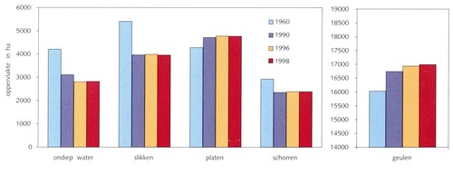
Oppervlaktes ondiep water, slikken, platen, schorren en geulen van de Westerschelde in 1960, 1990, 1996 en 1998
JPG file - 183.60 kB - 1 512 x 582 pixels
added on 2009-09-24328 viewsFrom reference Van Eck, B.T.M. (Ed.) (1999). De Scheldeatlas: een beeld ...Graph from Surface areas of shallow waters, mudflats, banks, salt ma...
Click here to return to the thumbnails overview |

